
Why a Lake’s Waterline Is Not Always the Legal Edge of a Lot
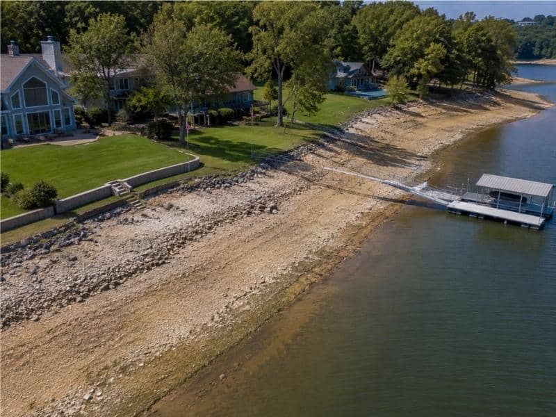
Waterfront owners often assume the edge of the water marks the edge of what they own. Boundary surveying proves otherwise on a regular basis. The recorded plat controls where the parcel ends, and the plat line and the shoreline can sit dozens of feet apart. Water rises and falls, banks wash away and get rebuilt, but the recorded geometry stays exactly where someone put it decades ago.
Reading the Original Lake Lot Plat
Most lakefront subdivisions were platted when the reservoir was built or shortly after. Those plats carry bearings, distances, curve data and a project boundary that the lake owner set for the water body itself. The lot lines run out to that boundary, which came from survey work and a fixed contour, not from wherever the water happened to sit on a given afternoon.
A surveyor rebuilds the plat by finding surviving markers and rerunning the recorded calls. The curve along the water side often follows a contour line measured many years ago, which means the line has a real mathematical definition even when nothing on the ground marks it. Reading that data correctly is what separates the parcel from the lake.
Measuring the Present Waterline as a Separate Feature
Crews still locate the current edge of water, and clients still want to see it on the drawing. The difference shows up in how the map labels the line. Today’s waterline appears as an observed feature tied to the date of the visit and the lake level at that moment, and never as a line that controls ownership.
That difference matters most when the reservoir sits low. A lot that seems to include a wide sandy beach in late summer may have water lapping at the same spot a few months later. The recorded boundary never moved an inch, and a careful drawing keeps the two lines far apart in both look and wording.
Reviewing Seawalls and Shoreline Alterations
Owners reshape shorelines all the time. Rock armor, poured walls, trucked-in sand, dredged coves and plain erosion all change the look of the bank without changing a single word in the deed. A wall built ten feet out into the water does not push the property line ten feet out with it.
Erosion moves in the other direction and worries owners more. Ground that washes away does not shrink the recorded parcel, though it can absolutely change what someone can build or use along the water. The survey records where the bank sits now, so the owner can see the real gap between the paper lot and the ground.
Relating Docks and Access Structures to the Upland Lot
Docks, boat lifts, ramps and stairs usually sit outside the private parcel altogether. Many lakes fall under a utility, an authority or a public agency that owns the land or holds flowage rights below a set elevation. Structures inside that zone need permits rather than ownership, so a permitted dock can serve a lot without belonging to it the way a garage does.
Permits often carry rules about size, placement, spacing from the neighbors and repair work. The surveyor locates the physical structure and shows how it relates to the upland lot. Questions about what the permit allows go back to the agency that issued it.
Helping Owners Read a Lakefront Survey Correctly
A good lakefront drawing tells the reader which line does what. Labels separate the boundary from the observed water edge, notes record the date and any known lake elevation and different linework keeps physical features from blending into legal ones. Reference elevations add context that a flat map cannot give on its own.
Owners who understand those habits ask sharper questions. They stop reading the shoreline as a property line and start asking about the recorded boundary, the rights below a certain elevation and the permits attached to their dock. Those are the things that actually decide what happens on the ground.
Frequently Asked Questions
Does the property line change when the lake level drops?
No. The recorded boundary stays where the plat and deed placed it, even when low water uncovers ground that used to sit underwater. That newly exposed strip often belongs to the lake owner or to the agency that holds rights below a set elevation, not to the neighboring lot owner.
Can a surveyor tell me whether I can build a new seawall?
A surveyor can show where the wall would sit compared with the boundary and the water edge, which answers the measurement side of the question. Permission to build usually rests with the lake authority, the local permit office or both. Those approvals come from a separate review with its own rules.
Why does my survey show two different lines near the water?
One line is the recorded lot boundary and the other is the water edge the crew observed on the day of the field visit. Keeping them apart stops readers from treating a changing physical feature as a fixed legal line. The notes on the drawing usually explain which line is which.